

A few of the businesses visible on the left side of the archive photo include The Wm. Davies Company’s provisions shop and The Royal Bank of Canada. On the right, there’s an ad for PEPs tablets for “colds, coughs…”
The block was demolished, and in 1928, construction began on Eaton’s College Street Store. The store opened in 1930 and primarily sold home furnishings. The building’s Seventh Floor also featured The Round Room restaurant and The Eaton Auditorium. Eaton’s closed this location in 1977. Today, this Art Deco landmark is known as College Park, and the historic Seventh-Floor event space is now called The Carlu (City of Toronto Archives, William James Family fonds, Fonds 1244, Item 500)

The beige brick buildings in the centre-right of the photos are a combination of two buildings. The house fronting Bathurst St was built in 1869 and was originally the residence of John Mulvey. The extension facing Adelaide St W was constructed between 1910 and 1911 for St. Mary’s Parish to serve as their literary and athletic club.
In the 1980s, these heritage-designated buildings became home to the Factory Theatre, which purchased the property in 1999 (City of Toronto Archives, Fonds 200, Series 1465, File 51, Item 62 – Urban Design photographs)

Although there are nearly 50 years between the two photos, the architecture of the streetscape remains relatively unchanged. One notable establishment is George’s Spaghetti House, visible on the right side of the archive photo. A live jazz club, it opened in 1956 under the ownership of Doug Cole and was also a popular Italian restaurant. In 1983, Mr. Cole sold the venue, and about a year later, the new owner relocated the jazz club to the second floor. George’s Spaghetti House closed in 1994, and the storefront became a diner.
From 2004 until approximately 2020, this space housed True Love Café. Since then, the storefront, which features red awnings, has remained vacant (City of Toronto Archives, Harvey R. Naylor fonds, Fonds 1526, File 71, Item 126)

Architects Symons and Rae designed a three-storey building in the mid-1910s that was incorporated into the existing house on the property’s north end. Initially, it was called Wilton Court Apartments, then Wilton Court Private Hotel, before changing to Westover Hotel, Stage 212, and finally Filmores Hotel in the 1980s.
Filmores closed on January 31, 2026. Plans are to construct a 44-storey, purpose-built rental tower incorporating the façade of Filmores Hotel (City of Toronto Archives, Toronto Planning Board fonds, Fonds 2032, Series 841, File 27, Item 21)

The left side of the archive photo shows the Bank of Montreal in the foreground, with Planters Nut & Chocolate Co. Ltd. behind it. On the right side of the vintage photo, Merrilee’s Home Bakery is visible in the foreground, followed by Top Notch Snack Bar and the Dominion Bank. The building in the background was an Eaton Co. warehouse. Notice the “Military Hospital Zone Slow” sign in the right foreground; it referred to the former Christie Street Hospital, which was located just past the railway bridge, on the west side at 352-390 Christie St.
Today, the former bank buildings have been converted into restaurants, while the Planters Peanut factory has been repurposed for office and commercial use (City of Toronto Archives, Fonds 200, Series 372, Sub Series 58, Item 1900 – Dept. of Public Works photographs)

The archive photo shows the streetscape over 75 years ago, when streetcars travelled along the two streets. On the left, there’s a Hires root beer sign, along with several shops, including United Cigar Stores, Laura Secord Candy Shops, and Uptown Lunch. In the distance, there is Stan Walker Furrier. In the foreground on the right is Frank Stollery’s men’s furnishings store.
In the present-day photo, the southeast corner on the left is now home to One Bloor, completed in 2017, while the One Bloor West condo tower is currently under construction at the southwest corner on the right (Toronto Public Library Pictures-R-4062 – James Victor Salmon photographer)

The archive photo shows Graf Bobby Café Restaurant Tavern, which specialized in Austrian cuisine, in the building in the left foreground. Constructed in 1855, this heritage-designated building at 36-40 Wellington St E was designed by architect John G. Howard. Today, it is home to Playa Cabana.
The vintage photo also shows part of the Perkins Block, built circa 1860, in the centre, and the St Lawrence Centre for the Arts on the right. Both of these buildings stand today. The parking lot visible in the right foreground has since been replaced by an office tower.
Leader Lane was named after The Leader newspaper that was once located in a building at the southwest corner of King St E and Leader Lane (City of Toronto Archives, Toronto Planning Board fonds, Fonds 2032, Series 841, File 69, Item 29)
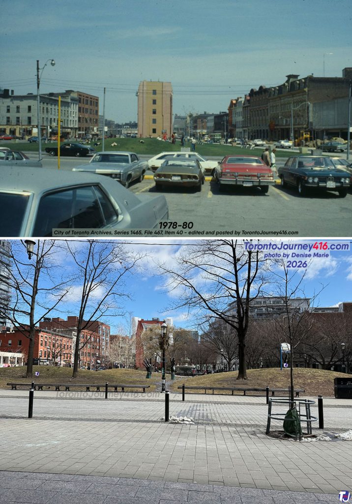
In 1980, Canadian artist Derek Michael Besant created the beautiful trompe-l’oeil mural on the back of the Gooderham Building, which overlooks Berczy Park. With a three-dimensional appearance, the faux facade artwork looks like it’s pinned to the building and blowing in the wind. It creates the illusion of additional windows on the back of the Gooderham Building, which actually has only five windows down the centre. The mural features the windows of the neighbouring Perkins Block at 41-43 Front St. E, which still stands to the right, although it’s now hidden by trees.
The parking lot in the foreground of the vintage photo is today the site of an office and retail building (City of Toronto Archives, Fonds 200, Series 1465, File 467, Item 40 – Urban Design photographs)

The archive photo shows Café New Orleans and Cheap Chic next door (City of Toronto Archives, Fonds 200, Series 1465, File 614, Item 29 – Urban Design photographs)

The building at the corner, constructed in 1913, was originally The Sterling Bank of Canada. It later became CIBC and eventually housed Pizza Pizza. The current photo shows the heritage-designated former bank building, whose storefront is home to Taco Bell, part of the 252 Church condo tower.
The background of the archive photo also shows the steeple of St. Michael’s Cathedral Basilica on the left, the CN Tower in the centre-right, and the clock tower of the old City Hall on the right (City of Toronto Archives, Harvey R. Naylor fonds, Fonds 1526, File 47, Item 46)

The 2021 photo shows the corner when it was home to an Esso gas station & Circle K convenience store, which closed in 2022. The 2026 photo shows early stages of construction of a 53-storey, purpose-built rental tower at 241 Church St.
Now mostly hidden by the new development, there are a few buildings to mention. In the left background is the George Vari Engineering and Computing Centre at Toronto Metropolitan University (formerly Ryerson University). The other buildings in the center background were constructed in phases between 1910 and 1950 for the Robert Simpson Company. In the 1990s, these heritage-designated Simpson buildings were converted into lofts, now known as The Merchandise Building

The archive photo shows Thrifty’s Sport Shop when it occupied the storefront. Over the years, the building has housed various businesses, including Public Optical, Gino’s Pizza, and Shawarma’s King.
Plans are underway to preserve the building’s historic façade and its neighbouring structures as part of a new 57-storey tower development named 60 Queen St East Condos (City of Toronto Archives, Harvey R. Naylor fonds, Fonds 1526, File 8, Item 87)

The archive photo features a portion of the Parkside Tavern, which opened its doors in April 1949. Ads in a local newspaper described the tavern as featuring a “lavish and well-appointed dining room… in a delightful, relaxing atmosphere.”
The Parkside was a popular tavern in the gay community. Above the Parkside, there was also a disco that went by various names in the 1970s, including Momma Cooper’s, Quasimodo’s, the Milk Bar, and Stages.
By 1981, it had gained a reputation as a top spot for draught beer, serving over 2,000 glasses daily to a diverse clientele. The Parkside Tavern closed in the mid-1980s, and since then, the building has housed a variety of businesses, including a grocery store and restaurants (City of Toronto Archives, Fonds 200, Series 1465, File 612, Item 19 – Urban Design photographs)
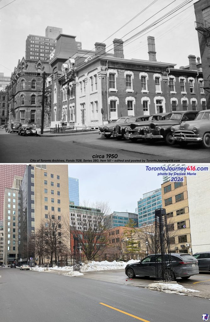
Both photos show a parking lot in the right foreground. The archive photo shows what was then known as Police Station No. 1 in the centre and Toronto Mortgage Chambers in the background on the left, at the corner of Toronto St.
Police Station No. 1 was built in the mid-1870s and originally served as both the Police Court and Fire Hall No. 5. After the fire hall on Lombard St was completed in 1887, firefighters from the Court St fire station moved to the new facility, leaving the Court St building primarily for police operations. Around 1901, Police Headquarters relocated from Court St to the newly constructed (Old) City Hall. In 1960, Police Station No. 1 moved to the Stewart Building on College St. Following this, the Court St building was demolished, and the site became a parking lot until 1997, when it was transformed into Courthouse Square Park, visible in the present-day photo.
The building that housed the Toronto Mortgage Chambers was originally known as the Building & Loan Association Chambers, which was constructed in 1879. It was demolished in the early 1960s to make way for the current 11-storey office building, which features black glass and cream-coloured brick and is located at 15 Toronto St (City of Toronto Archives, Strathy Smith fonds, Fonds 1128, Series 380, Item 161)

The three-storey building was once home to the pharmaceutical drug manufacturer Powell Chemical Company, as shown in the archive photo. Known then as the Powell Building, it got its uniquely angled façade in the early 1920s when the city took a portion of the building for a new diagonal piece of roadway for the crosstown streetcar line. In later years, the building housed Teela Digest Publications’ office and a Hakim Optical location before becoming vacant.
In 2023, Toronto Metropolitan University (formerly Ryerson University) acquired the city-owned property. Due to safety concerns, the century-old building was demolished in 2024 (City of Toronto Archives, Fonds 200, Series 372, Sub Series 3 Item 500 – Dept. of Public Works photographs)
SOURCE
- City of Toronto Heritage Register
- City of Toronto Heritage Register: 43 Front St E (Hutchinson Building, looking south on Leader Ln towards Wellington St E)
- City of Toronto Heritage Register: 36-40 Wellington St E (Perkins Block, looking south on Leader Ln towards Wellington St E)
- Heritage Toronto: Robert Simpson Co. Warehouse plaque (northeast corner of Dundas St E & Church St)
- Heritage Toronto: Simpsons Mail-Order Warehouse Dalhousie Street Extension plaque (northeast corner of Dundas St E & Church St)
- Heritage Toronto
- Ontario Heritage Trust
- Biographical Dictionary of Architects in Canada
- Factory Theatre: Our Building (Factory Theatre, northeast corner of Bathurst St & Adelaide St W)
- The Globe Newspaper Archives: Oct 20, 1911, pg 8 (St. Mary’s Parish Literary & Athletic Club, northeast corner of Bathurst St & Adelaide St W)
- The Globe Newspaper Archives: Oct 31, 1930, pg 13 (Eaton’s College Street Store, southwest corner of Yonge St & College St)
- Toronto Star Newspaper Archives: Feb 7, 1977, pg C1 (Eaton’s College Street Store, southwest corner of Yonge St & College St)
- Toronto Star Newspaper Archives: Mar 23, 1979, pg B10 (Eaton’s College Street Store, southwest corner of Yonge St & College St)
- The Globe and Mail Newspaper Archives: Oct 16, 1956, pg 18 (George’s Spaghetti House, looking northwest along Dundas St E from Sherbourne St)
- The Globe and Mail Newspaper Archives: Aug 31, 1983, pg 15 (George’s Spaghetti House, looking northwest along Dundas St E from Sherbourne St)
- The Globe and Mail Newspaper Archives: Sep 19, 1980, pg 13 (Gooderham Building mural, looking east from Scott St)
- The Globe and Mail Newspaper Archives: Apr 12, 1949, pg 21 (Parkside Tavern, looking north from Breadalbane St at Yonge St)
- The Toronto Star Newspaper Archives: Dec 21, 1978, pg E8 (Parkside Tavern, looking north from Breadalbane St at Yonge St)
- The Toronto Star Newspaper Archives: May 9, 1981, pg A3 (Parkside Tavern, looking north from Breadalbane St at Yonge St)
- The Globe and Mail Newspaper Archives: Mar 8, 1986, pg A17 (Parkside Tavern, looking north from Breadalbane St at Yonge St)
- The Globe Newspaper Archives: Dec 24, 1874, pg 4 (Police Court & Fire Hall, looking northwest on Court St, west of Church St)
- The Globe Newspaper Archives: Feb 9, 1876, pg 2 (Police Court & Fire Hall, looking northwest on Court St, west of Church St)
- The Globe and Mail Newspaper Archives: Sep 3, 1960, pg 5 (Police Court & Fire Hall, looking northwest on Court St, west of Church St)
- The Globe and Mail Newspaper Archives: Dec 14, 1995, pg D3 (Courthouse Square Park, looking northwest on Court St, west of Church St)
- GBCA: Heritage Impact Assessment for 15 Toronto St, dated Aug 24, 2023 (15 Toronto St, looking northwest on Court St, west of Church St)
- The Globe Newspaper Archives: Nov 15, 1922, pg 14 (Powell Building, northeast corner of Dundas St E & Victoria St)
- Photos: Denise Marie for TorontoJourney416
- Vintage Photos: City of Toronto Archives, Toronto Public Library, Archives of Ontario & CNE Heritage
- City of Toronto: Maps
- Toronto City Directory, courtesy of Toronto Public Library
