Past & Present – Part 112

Posted:

August 26,1983/September 27, 2026 - Looking east towards Yonge St from Dundas St W, in the Downtown Yonge area of Toronto. 

A few establishments visible in the archive photo include Coles the Book People, Rockwell Jeans, Mr Submarine, Franks Hamburgers and Pinball Games with the Eaton Centre on the right foreground
August 26,1983/September 27, 2026 – Looking east towards Yonge St from Dundas St W, in the Downtown Yonge area of Toronto.

A few establishments visible in the archive photo include Coles the Book People, Rockwell Jeans, Mr Submarine, Franks Hamburgers and Pinball Games with the Eaton Centre on the right foreground (City of Toronto Archives, Ellis Wiley fonds, Fonds 124, File 8, Item 195)

December 10, 1920/September 27, 2026 - Looking west on Bloor St W from Christie St in the Koreatown and Christie Pits neighbourhoods of Toronto.

The archive photo shows the street over 100 years ago. It features horse-drawn wagons, a man holding a sign that reads "Dec 10, 1920," labourers working on the tracks and a streetcar in the distance. On the right side of the old photo, Willowvale Park is visible, which is now known as Christie Pits Park
December 10, 1920/September 27, 2026 – Looking west on Bloor St W from Christie St in the Koreatown and Christie Pits neighbourhoods of Toronto.

The archive photo shows the street over 100 years ago. It features horse-drawn wagons, a man holding a sign that reads “Dec 10, 1920,” labourers working on the tracks and a streetcar in the distance. On the right side of the old photo, Willowvale Park is visible, which is now known as Christie Pits Park (City of Toronto Archives, Fonds 200, Series 372, Sub Series 58, Item 909 – Dept. of Public Works photographs)

Between 1983-89/September 17, 2026 – Looking west along Bloor St W towards Jane St in the Bloor West Village neighbourhood of Toronto. 

A few establishments visible in the archive photo include Mercer Floor Coverings, The Whimsical Touch, Bloor Jane Food Market, and across Jane St, the Odeon Humber Theatre (City of Toronto Archives, Fonds 200, Series 1465, File 515, Item 1 - Urban Design photographs)
Between 1983-89/September 17, 2026 – Looking west along Bloor St W towards Jane St in the Bloor West Village neighbourhood of Toronto.

A few establishments visible in the archive photo include Mercer Floor Coverings, The Whimsical Touch, Bloor Jane Food Market, and across Jane St, the Odeon Humber Theatre (City of Toronto Archives, Fonds 200, Series 1465, File 515, Item 1 – Urban Design photographs)

Between 1939-41/September 27, 2026 - Looking southeast towards the corner of Yonge St and Church St in the Yorkville and Rosedale-Moore Park neighbourhoods of Toronto.

The archive photo shows a Sky Chief Gasoline billboard and the Hotel Morrissey. In 1936, a few years before the old photo was taken, Willie Morrissey, a colourful racehorse owner and boxing promoter, bought the hotel, originally constructed as an apartment building. He renamed it the Hotel Morrissey. In the late 1940s, it became known as the Morrissey Tavern. By the mid-1960s, it was owned and operated by the Dongas family and became a favourite hangout for local residents as well as university students, who affectionately called it "The Mo."

The tavern closed its doors in September 1997, and the building was replaced by the present-day structure, completed in 2003. The storefront previously served as a Shoppers Drug Mart and is now home to the Toronto Islamic Centre & Community Services
Between 1939-41/September 27, 2026 – Looking southeast towards the corner of Yonge St and Church St in the Yorkville and Rosedale-Moore Park neighbourhoods of Toronto.

The archive photo shows a Sky Chief Gasoline billboard and the Hotel Morrissey. In 1936, a few years before the old photo was taken, Willie Morrissey, a colourful racehorse owner and boxing promoter, bought the hotel, originally constructed as an apartment building. He renamed it the Hotel Morrissey. In the late 1940s, it became known as the Morrissey Tavern. By the mid-1960s, it was owned and operated by the Dongas family and became a favourite hangout for local residents as well as university students, who affectionately called it “The Mo.”

The tavern closed its doors in September 1997, and the building was replaced by the present-day structure, completed in 2003. The storefront previously served as a Shoppers Drug Mart and is now home to the Toronto Islamic Centre & Community Services (City of Toronto Archives, E.L. Ruddy Company fonds, Fonds 1488, Series 1230, Item 5712)

Mar 12, 1951/September 27, 2026 - Looking north up Dufferin St from Bloor St W, in the Bloorcourt and Bloordale Village neighbourhoods of Toronto. 

A few establishments visible in the archive photo include the Joy Oil Company gas station and the Bell Telephone Company of Canada on the left, while Cushing Drugs and Hurst Bros Real Estate are located on the right. Today, the former gas station site is occupied by the TTC Dufferin Subway Station, while Bell continues to operate at the same location
Mar 12, 1951/September 27, 2026 – Looking north up Dufferin St from Bloor St W, in the Bloorcourt and Bloordale Village neighbourhoods of Toronto.

A few establishments visible in the archive photo include the Joy Oil Company gas station and the Bell Telephone Company of Canada on the left, while Cushing Drugs and Hurst Bros Real Estate are located on the right. Today, the former gas station site is occupied by the TTC Dufferin Subway Station, while Bell continues to operate at the same location (City of Toronto Archives, Fonds 200, Series 372, Sub Series 58, Item 2137 – Dept. of Public Works photographs)

1890s/September 27, 2026 – Looking northeast along Richmond St, towards Yonge St and the Confederation Life Building, in the Downtown Yonge area of Toronto.

The majestic building was constructed between 1890 and 1892 and designed by the architectural firm Knox, Elliot & Jarvis. It spans an entire block from Yonge St to Victoria St. The Confederation Life Association used this building as its headquarters until 1955. In 1973, it was added to the city's heritage register.

In 1981, a fire swept through the historic building while the landmark was undergoing a $13 million renovation. In the days leading up to the fire, workers had putting on a new roof using hot tar. Although the heritage building suffered significant damage, city engineers determined it was stable enough to be saved from demolition, and most of the structure was later restored. Today, the building is home to many shops, restaurants and offices.

In the left foreground of the present-day photo is what was originally the Robert Simpson Co. store and, more recently, was home to The Bay, which closed in 2025
1890s/September 27, 2026 – Looking northeast along Richmond St, towards Yonge St and the Confederation Life Building, in the Downtown Yonge area of Toronto.

The majestic building was constructed between 1890 and 1892 and designed by the architectural firm Knox, Elliot & Jarvis. It spans an entire block from Yonge St to Victoria St. The Confederation Life Association used this building as its headquarters until 1955. In 1973, it was added to the city’s heritage register.

In 1981, a fire swept through the historic building while the landmark was undergoing a $13 million renovation. In the days leading up to the fire, workers had putting on a new roof using hot tar. Although the heritage building suffered significant damage, city engineers determined it was stable enough to be saved from demolition, and most of the structure was later restored. Today, the building is home to many shops, restaurants and offices.

In the left foreground of the present-day photo is what was originally the Robert Simpson Co. store and, more recently, was home to The Bay, which closed in 2025 (Toronto Public Library E9-90)

July 29, 1925/September 17, 2026 - Looking east on Bloor St W towards Perth Ave, east of Dundas St W from the railway overpass in the Junction Triangle of Toronto.

The archive photo shows TTC tracklaying across what was known then as the "Bloor Street gap." This gap referred to the stretch of Bloor St W from Lansdowne Ave to Dundas St W. This work bridged the gap across Bloor St W, allowing the Bloor streetcars to run right across the city from Luttrell Ave in the east to Jane St in the west. The streetcar tracks were removed following the opening of the Bloor-Danforth subway (Line 2) in 1966. In a Toronto Daily Star article, Robert Thomas Allen humorously wrote, "The new subway will put an end to the notorious Bloor Sardine Syndrome."

The track work in the vintage photo coincided with the 1925 construction of the railway underpass, where Bloor St W dips down to pass beneath the railway bridge, from where both photos were taken. Before the underpass was built, railway tracks crossed Bloor St W (at street level), west of Perth Ave. The underpass improved pedestrian safety and traffic flow. This section of the rail line was later abandoned and, since 2009, has been part of the car-free, multi-use trail called the West Toronto Railpath
July 29, 1925/September 17, 2026 – Looking east on Bloor St W towards Perth Ave, east of Dundas St W from the railway overpass in the Junction Triangle of Toronto.

The archive photo shows TTC tracklaying across what was known then as the “Bloor Street gap.” This gap referred to the stretch of Bloor St W from Lansdowne Ave to Dundas St W. This work bridged the gap across Bloor St W, allowing the Bloor streetcars to run right across the city from Luttrell Ave in the east to Jane St in the west. The streetcar tracks were removed following the opening of the Bloor-Danforth subway (Line 2) in 1966. In a Toronto Daily Star article, Robert Thomas Allen humorously wrote, “The new subway will put an end to the notorious Bloor Sardine Syndrome.”

The track work in the vintage photo coincided with the 1925 construction of the railway underpass, where Bloor St W dips down to pass beneath the railway bridge, from where both photos were taken. Before the underpass was built, railway tracks crossed Bloor St W (at street level), west of Perth Ave. The underpass improved pedestrian safety and traffic flow. This section of the rail line was later abandoned and, since 2009, has been part of the car-free, multi-use trail called the West Toronto Railpath (City of Toronto Archives, Toronto Transit Commission fonds, Fonds 16, Series 71, Item 3950)

1972/September 27, 2026 - Looking southeast towards the corner of Spadina Ave and Sussex Ave, in the Harbord Village neighbourhood of Toronto.

The businesses in the archive photo include Spadina Food Market and William Funeral Chapel. Today, the corner building is home to Bhoj Indian Cuisine, while the former funeral chapel serves as the University of Toronto's Daniels Architecture Commons
1972/September 27, 2026 – Looking southeast towards the corner of Spadina Ave and Sussex Ave, in the Harbord Village neighbourhood of Toronto.

The businesses in the archive photo include Spadina Food Market and William Funeral Chapel. Today, the corner building is home to Bhoj Indian Cuisine, while the former funeral chapel serves as the University of Toronto’s Daniels Architecture Commons (City of Toronto Archives, Toronto Planning Board fonds, Fonds 2032, Series 841, File 55, Item 11)
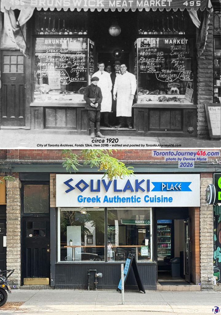
Circa 1920/July 25, 2026 - Looking south towards 495 Bloor St W, between Brunswick Ave and Borden St, in The Annex neighbourhood of Toronto. 

The archive photo shows the storefront when it was home to the Brunswick Meat Market. Today, Souvlaki Place occupies the space
Circa 1920/July 25, 2026 – Looking south towards 495 Bloor St W, between Brunswick Ave and Borden St, in The Annex neighbourhood of Toronto.

The archive photo shows the storefront when it was home to the Brunswick Meat Market. Today, Souvlaki Place occupies the space (City of Toronto Archives, William James Family fonds, Fonds 1244, Item 339B)
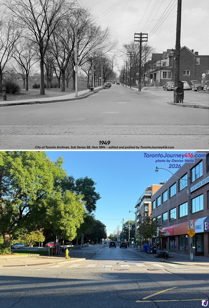
March 28, 1949/September 6, 2026 - Looking north up Christie St from Bloor St W, in the Christie Pits and Seaton Village neighbourhoods of Toronto.

The archive photo shows the intersection over 75 years ago. On the left was what was then known as Willowvale Park, and on the right were Frank McKee's service station and Trinity Taxi. The vintage photo also shows when a streetcar line travelled along Bloor St, as well as the "man-horse-dog" water fountain and trough once on the west side of Christie St. At that time, this section (about 80 m) of Christie St was a two-way street before the southbound split was added to Grace St.

In 1983, the greenspace and sports facility was officially renamed Christie Pits Park. The site of the gas station is today home to Bloor Park Medical Centre
March 28, 1949/September 6, 2026 – Looking north up Christie St from Bloor St W, in the Christie Pits and Seaton Village neighbourhoods of Toronto.

The archive photo shows the intersection over 75 years ago. On the left was what was then known as Willowvale Park, and on the right were Frank McKee’s service station and Trinity Taxi. The vintage photo also shows when a streetcar line travelled along Bloor St, as well as the “man-horse-dog” water fountain and trough once on the west side of Christie St. At that time, this section (about 80 m) of Christie St was a two-way street before the southbound split was added to Grace St.

In 1983, the greenspace and sports facility was officially renamed Christie Pits Park. The site of the gas station is today home to Bloor Park Medical Centre (City of Toronto Archives, Fonds 200, Series 372, Sub Series 58, Item 1894 – Dept. of Public Works photographs)
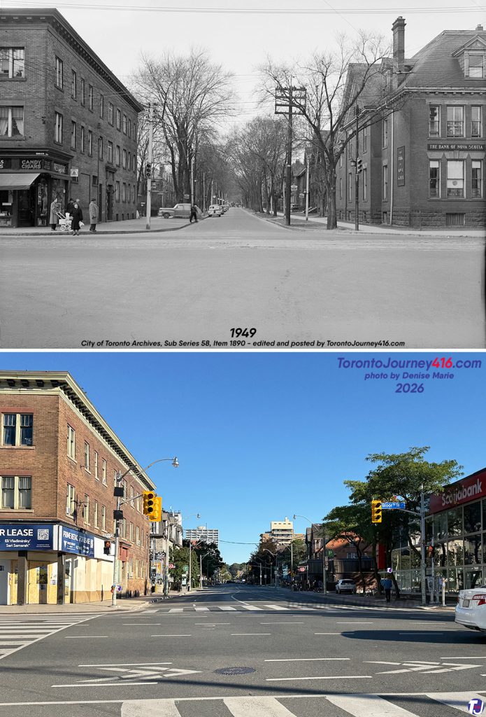
March 28, 1949/September 6, 2026 - Looking north up Spadina Rd from Bloor St W in The Annex neighbourhood of Toronto.

The archive photo shows the York Apartments on the left, the Bank of Nova Scotia on the right and the streetcar track that once ran along Bloor St.

The present-day photo shows a widened roadway. The York Apartments, which date back to 1912, still stand today, while Scotiabank continues to operate at the northeast corner, now in a contemporary building
March 28, 1949/September 6, 2026 – Looking north up Spadina Rd from Bloor St W in The Annex neighbourhood of Toronto.

The archive photo shows the York Apartments on the left, the Bank of Nova Scotia on the right and the streetcar track that once ran along Bloor St.

The present-day photo shows a widened roadway. The York Apartments, which date back to 1912, still stand today, while Scotiabank continues to operate at the northeast corner, now in a contemporary building (City of Toronto Archives, Fonds 200, Series 372, Sub Series 58, Item 1890 – Dept. of Public Works photographs)

1937/August 29, 2026 – Looking southwest along Bloor St W from east of Jane St in the Lambton Bloor West Village, Swansea and Lambton Baby Point neighbourhoods in Toronto.

The archive photo shows the streetscape from nearly 90 years ago. The left side of the vintage photo shows the former TTC Jane St Loop, along with Tamblyn Drugs, once located at 2445 Bloor St W
1937/August 29, 2026 – Looking southwest along Bloor St W from east of Jane St in the Lambton Bloor West Village, Swansea and Lambton Baby Point neighbourhoods in Toronto.

The archive photo shows the streetscape from nearly 90 years ago. The left side of the vintage photo shows the former TTC Jane St Loop, along with Tamblyn Drugs, once located at 2445 Bloor St W (City of Toronto Archives, E.L. Ruddy Company fonds, Fonds 1488, Series 1230, Item 4589)

Circa 1945/August 29, 2026 - Looking southwest towards Lake Shore Blvd and Fourth St in the New Toronto neighbourhood of Toronto.

The archive photo shows the New Toronto Hotel, constructed in the 1930s. Over the years, the hotel has had a few name changes, including Boulevard Inn and Jay-Jay's Inn, and is now known as the Westlake Boutique Hotel
Circa 1945/August 29, 2026 – Looking southwest towards Lake Shore Blvd and Fourth St in the New Toronto neighbourhood of Toronto.

The archive photo shows the New Toronto Hotel, constructed in the 1930s. Over the years, the hotel has had a few name changes, including Boulevard Inn and Jay-Jay’s Inn, and is now known as the Westlake Boutique Hotel (City of Toronto Archives, Alexandra Studio fonds, Fonds 1257, Series 1057, Item 530)
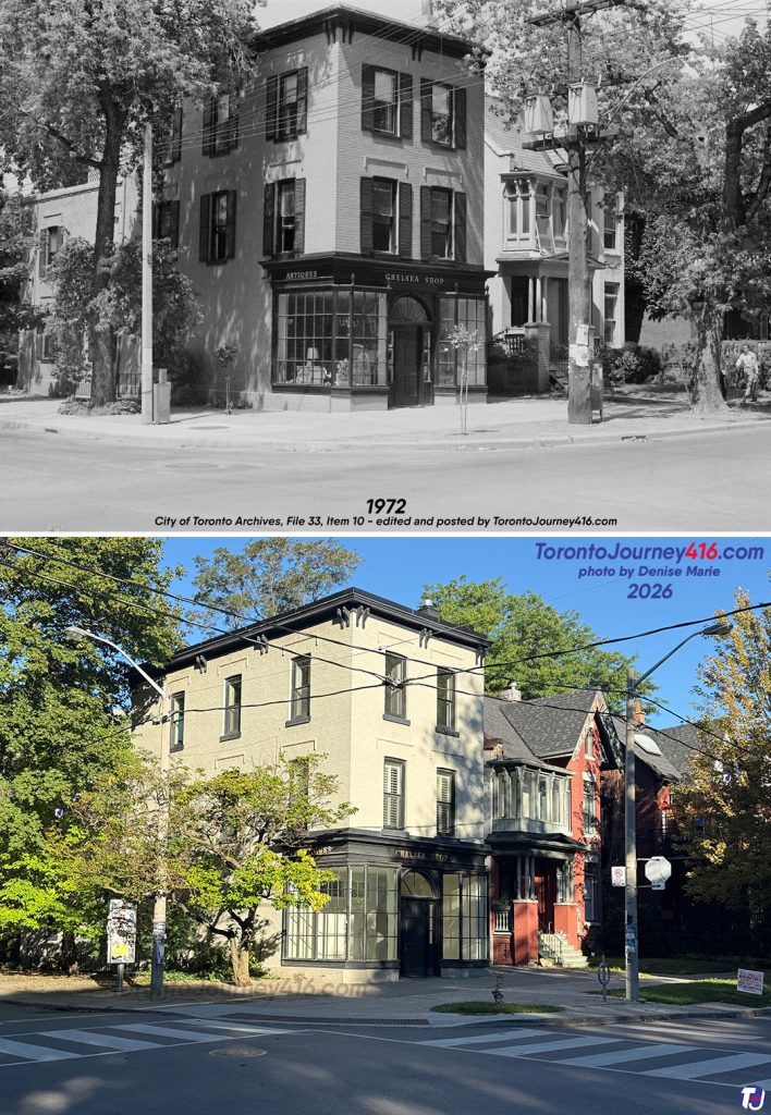
1972/September 6, 2026 – Looking northwest towards the corner of Huron St and Sussex Ave, in the Huron Sussex neighbourhood near the University of Toronto.

The three-storey, heritage-designated building at the corner was constructed in the late 1880s for Thomas Charlton's grocery store, at a cost of $3,000. It served as his store until approximately 1905. After that, it continued to function as various grocery stores and later as a butcher shop until 1959.

In the early 1960s, it became home to the Chelsea Shop, which sold antiques until it closed in approximately 1990. Over the years, it has also served residential purposes. The storefront still displays the signs "Chelsea Shop" and "Antiques." In recent decades, the building has housed various businesses, including Westwood Creative Artists, which has since relocated
1972/September 6, 2026 – Looking northwest towards the corner of Huron St and Sussex Ave, in the Huron Sussex neighbourhood near the University of Toronto.

The three-storey, heritage-designated building at the corner was constructed in the late 1880s for Thomas Charlton’s grocery store, at a cost of $3,000. It served as his store until approximately 1905. After that, it continued to function as various grocery stores and later as a butcher shop until 1959.

In the early 1960s, it became home to the Chelsea Shop, which sold antiques until it closed in approximately 1990. Over the years, it has also served residential purposes. The storefront still displays the signs “Chelsea Shop” and “Antiques.” In recent decades, the building has housed various businesses, including Westwood Creative Artists, which has since relocated (City of Toronto Archives, Toronto Planning Board fonds, Fonds 2032, Series 841, File 33, Item 10)

Between 1930-35/September 17, 2026 – Looking southeast across Bloor St W from west of Dufferin St in the Bloordale Village neighbourhood of Toronto. The archive photo shows the National Cash Register Company building on the left, which was demolished long ago, and part of Kent Public School on the right. Today, the former school is part of a mixed-use development called the Marlow, shown under construction in the present-day photo
Between 1930-35/September 17, 2026 – Looking southeast across Bloor St W from west of Dufferin St in the Bloordale Village neighbourhood of Toronto.

The archive photo shows the National Cash Register Company building on the left, which was demolished long ago, and part of Kent Public School on the right. Today, the former school is part of a mixed-use development called the Marlow, shown under construction in the present-day photo (City of Toronto Archives, E.L. Ruddy Company fonds, Fonds 1488, Series 1230, Item 4144)

SOURCE
  • City of Toronto Heritage Register
  • City of Toronto Heritage Register: 20 Richmond St E (Confederation Life Building, looking northeast along Richmond St towards Yonge St)
  • Heritage Toronto
  • Heritage Toronto plaque: Confederation Life Building (looking northeast along Richmond St towards Yonge St)
  • Ontario Heritage Trust
  • The Globe and Mail Newspaper Archives: Feb 8, 1973, pg 40 (Morrissey Tavern, looking southeast at Yonge St & Church St)
  • The Toronto Star Newspaper Archives: Sep 14, 1997, pg A6 (Morrissey Tavern, looking southeast at Yonge St & Church St)
  • The Toronto Star Newspaper Archives: May 8, 1999, pgs P1 & P11 (Morrissey Tavern, looking southeast at Yonge St & Church St)
  • LoopNet: 817 Yonge St (Looking southeast at Yonge St & Church St)
  • The Globe and Mail Newspaper Archives: Jun 18, 1981, pg 5 (Confederation Life Building, looking northeast along Richmond St towards Yonge St)
  • The Toronto Star Newspaper Archives: Jun 18, 1981, pgs A1 & A14 (Confederation Life Building, looking northeast along Richmond St towards Yonge St)
  • The Toronto Mail Newspaper Archives: Aug 18, 1887, pg 6 (Thomas Charlton grocery, northwest corner of Huron St & Sussex Ave)
  • The Globe Newspaper Archives: Sep 18, 1924, pg 11 (Looking east on Bloor St W towards Perth Ave)
  • The Toronto Daily Star Newspaper Archives: Dec 20, 1924, pg 1 (Looking east on Bloor St W towards Perth Ave)
  • The Globe Newspaper Archives: Jul 14, 1925, pg 9 (Looking east on Bloor St W towards Perth Ave)
  • The Toronto Daily Star Newspaper Archives: Feb 9, 1966, pg 7 (Looking east on Bloor St W towards Perth Ave)
  • Friends of the West Toronto Railpath: History (Looking east on Bloor St W towards Perth Ave)
  • Vintage Photos: City of Toronto Archives, Toronto Public Library, Archives of Ontario & CNE Heritage
  • City of Toronto: Maps
  • Toronto City Directory, courtesy of Toronto Public Library

LEAVE A REPLY

Please enter your comment!
Please enter your name here

Stay Connected

1,040FansLike
34,068FollowersFollow
118FollowersFollow
8,025FollowersFollow