Past & Present – Part 108

Posted:

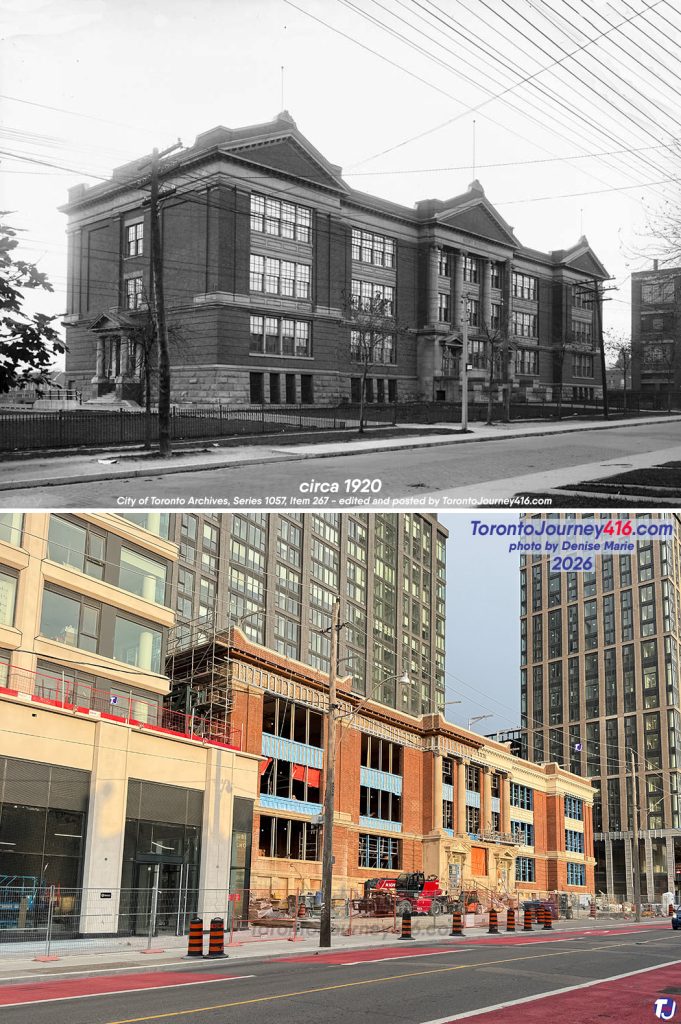
Circa 1920/August 22, 2026 – Looking northwest from Dufferin St just south of Bloor St W in the Brockton Village and Dufferin Grove neighbourhoods of Toronto.

The Kent Senior Public School, located at 980 Dufferin St, was established in 1907 and designed in the Edwardian Classical style by architect C.H. Bishop. It opened the following year and was named in honour of Herbert A. E. Kent, who served as a Toronto trustee for 21 years.

The school closed in 2012 due to declining enrollment and was declared surplus in 2016 before being sold to developers. In 2020, the building received heritage designation from the city. The site is currently undergoing redevelopment into a mixed-use project known as the Marlow
Circa 1920/August 22, 2026 – Looking northwest from Dufferin St just south of Bloor St W in the Brockton Village and Dufferin Grove neighbourhoods of Toronto.

The Kent Senior Public School, located at 980 Dufferin St, was established in 1907 and designed in the Edwardian Classical style by architect C.H. Bishop. It opened the following year and was named in honour of Herbert A. E. Kent, who served as a Toronto trustee for 21 years.

The school closed in 2012 due to declining enrollment and was declared surplus in 2016 before being sold to developers. In 2020, the building received heritage designation from the city. The site is currently undergoing redevelopment into a mixed-use project known as the Marlow (City of Toronto Archives, Alexandra Studio fonds, Fonds 1257, Series 1057, Item 267)

Circa 1912/August 22, 2026 – Looking northwest towards the corner of Bloor St W and Dufferin St in the Bloordale Village neighbourhood of Toronto.

The archive photo shows when the Dufferin Hotel was located at the corner. The hotel first appeared in the 1889 edition of the Toronto City Directory, and by 1892, Angus Kerr was listed as the operator of the establishment. Also known as the Dufferin House, in 1905, the hotel lost its liquor license due to a "lack of accommodation" and opposition from locals. Mr. Kerr continued to be listed as residing at the address until the 1912 directory
Circa 1912/August 22, 2026 – Looking northwest towards the corner of Bloor St W and Dufferin St in the Bloordale Village neighbourhood of Toronto.

The archive photo shows when the Dufferin Hotel was located at the corner. The hotel first appeared in the 1889 edition of the Toronto City Directory, and by 1892, Angus Kerr was listed as the operator of the establishment. Also known as the Dufferin House, in 1905, the hotel lost its liquor license due to a “lack of accommodation” and opposition from locals. Mr. Kerr continued to be listed as residing at the address until the 1912 directory (Toronto Public Library Pictures-R-4517)
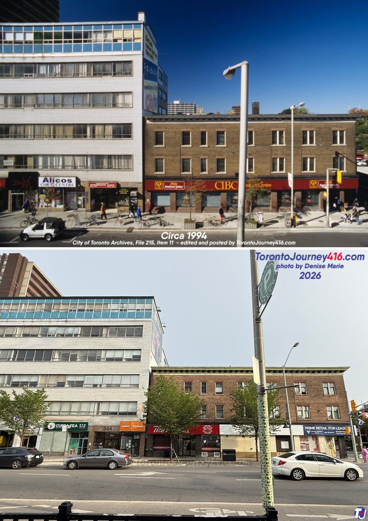
Circa 1994/August 22, 2026 - Looking north across Bloor St W from west of Spadina Ave/Rd in The Annex neighbourhood of Toronto.

A few establishments visible in the archive photo, from right to left, include CIBC Banking Centre, Simman’s Jewellers, Chiropractic Clinic, Alicos Copy Center, and S.W.A.K. gifts
Circa 1994/August 22, 2026 – Looking north across Bloor St W from west of Spadina Ave/Rd in The Annex neighbourhood of Toronto.

A few establishments visible in the archive photo, from right to left, include CIBC Banking Centre, Simman’s Jewellers, Chiropractic Clinic, Alicos Copy Center, and S.W.A.K. gifts (City of Toronto Archives, Fonds 200, Series 1465, File 215, Item 11 – Urban Design photographs)
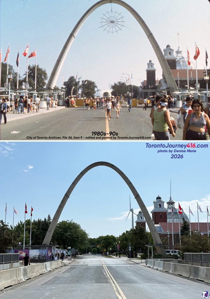
Between 1980s-90s/August 2, 2026 - Looking south toward the Dufferin Gate near the foot of Dufferin St at Exhibition Place. 

The Dufferin Gate was completed for the opening of the 1959 CNE. Architect Arthur G Keith of the firm AD Margison and Associates designed the parabolic archway in the Mid-Century Modern style. The Dufferin Gate stands 20 m (65 ft) tall and cost over $250,000 to build. The city granted the structure heritage status in 1993.

Notice in the archive photo that the admission booths were located just outside the Dufferin Gate. The Government Building is also visible in the background on the right, which is home to the Medieval Times Dinner & Tournament
Between 1980s-90s/August 2, 2026 – Looking south toward the Dufferin Gate near the foot of Dufferin St at Exhibition Place.

The Dufferin Gate was completed for the opening of the 1959 CNE. Architect Arthur G Keith of the firm AD Margison and Associates designed the parabolic archway in the Mid-Century Modern style. The Dufferin Gate stands 20 m (65 ft) tall and cost over $250,000 to build. The city granted the structure heritage status in 1993.

Notice in the archive photo that the admission booths were located just outside the Dufferin Gate. The Government Building is also visible in the background on the right, which is home to the Medieval Times Dinner & Tournament (City of Toronto Archives, Fonds 200, Series 1465, File 56, Item 9 – Urban Design photographs)
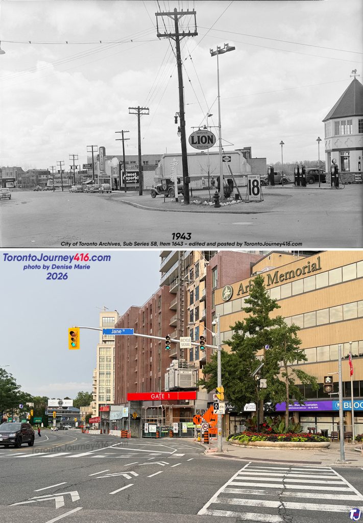
April 13, 1943/August 22, 2026 – Looking west along Bloor St W from Jane St in the Lambton Baby Point neighbourhood of Toronto.

The archive photo shows the Lion Service Station on the corner when a gallon of gas was 18¢, or about 4¢ a litre. A little further down the street was Loblaw Groceteria.

The present-day photo shows the construction of a mixed-use building called the Bijou on Bloor. This stretch was once the site of the Humber Cinemas, along with several other buildings that were torn down to make way for the new condo
April 13, 1943/August 22, 2026 – Looking west along Bloor St W from Jane St in the Lambton Baby Point neighbourhood of Toronto.

The archive photo shows the Lion Service Station on the corner when a gallon of gas was 18¢, or about 4¢ a litre. A little further down the street was Loblaw Groceteria.

The present-day photo shows the construction of a mixed-use building called the Bijou on Bloor. This stretch was once the site of the Humber Cinemas, along with several other buildings that were torn down to make way for the new condo (City of Toronto Archives, Fonds 200, Series 372, Sub Series 58, Item 1643 – Dept. of Public Works photographs)
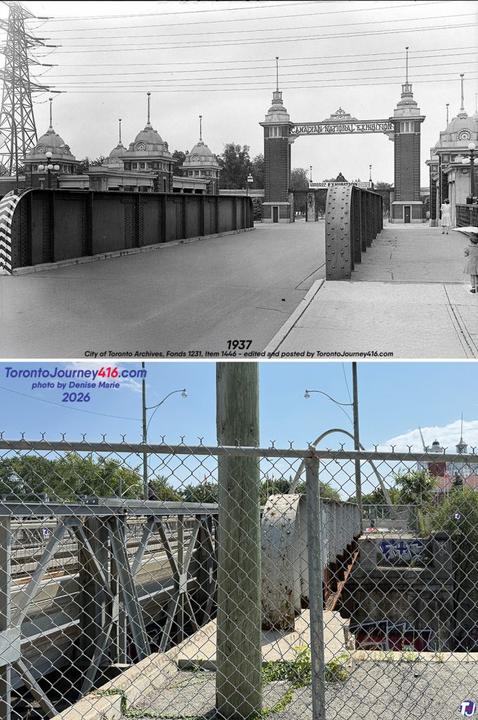
July 15, 1937/August 22, 2026 - Looking southeast toward Dufferin Gate near the foot of Dufferin St at Exhibition Place. 

The archive photo shows the second Dufferin Gate, built in 1912. Architect George W. Gouinlock designed the gate, which was replaced in the late 1950s by today’s parabolic archway to make way for the Gardiner Expressway (City of Toronto Archives, Fonds 1231, Item 1446 - James Victor Salmon photographer)
July 15, 1937/August 22, 2026 – Looking southeast toward Dufferin Gate near the foot of Dufferin St at Exhibition Place.

The archive photo shows the second Dufferin Gate, built in 1912. Architect George W. Gouinlock designed the gate, which was replaced in the late 1950s by today’s parabolic archway to make way for the Gardiner Expressway (City of Toronto Archives, Fonds 1231, Item 1446 – James Victor Salmon photographer)
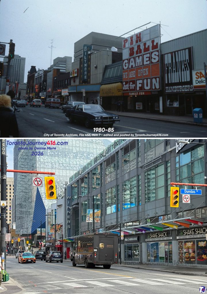
Between 1980-85/July 25, 2026 – Looking northeast up Yonge St from Dundas St, in the Downtown Yonge area of Toronto. 

A few businesses visible on the right side of the archive photo include Sa-Gi's Delicatessen, Franks Hamburgers, Pinball Games, Pasta Plus, Biltmore Theatre and Cheapies Records & Tapes. Today, this stretch of the block is home to The Tenor - a retail, entertainment, and office complex
Between 1980-85/July 25, 2026 – Looking northeast up Yonge St from Dundas St, in the Downtown Yonge area of Toronto.

A few businesses visible on the right side of the archive photo include Sa-Gi’s Delicatessen, Franks Hamburgers, Pinball Games, Pasta Plus, Biltmore Theatre and Cheapies Records & Tapes. Today, this stretch of the block is home to The Tenor – a retail, entertainment, and office complex (City of Toronto Archives, Fonds 200, Series 1465, File 456, Item 7 – Urban Design photographs)

Between 1930-35/July 25, 2026 – Looking southeast towards the corner of Dundas St E and Bond St, in the Garden District of Toronto. The archive photo features the British-American Gasoline Service Station and Grant A. Edwards Auto Repairs at the corner. Note the old-fashioned spelling of "gasoline." In the right background of both images, the buildings of St. Michael's Catholic Cathedral Basilica are visible, including the school on the far right and the church featuring three dormer windows
Between 1930-35/July 25, 2026 – Looking southeast towards the corner of Dundas St E and Bond St, in the Garden District of Toronto.

The archive photo features the British-American Gasoline Service Station and Grant A. Edwards Auto Repairs at the corner. Note the old-fashioned spelling of “gasoline.”

In the right background of both images, the buildings of St. Michael’s Catholic Cathedral Basilica are visible, including the school on the far right and the church featuring three dormer windows (City of Toronto Archives, E.L. Ruddy Company fonds, Fonds 1488, Series 1230, Item 4158)
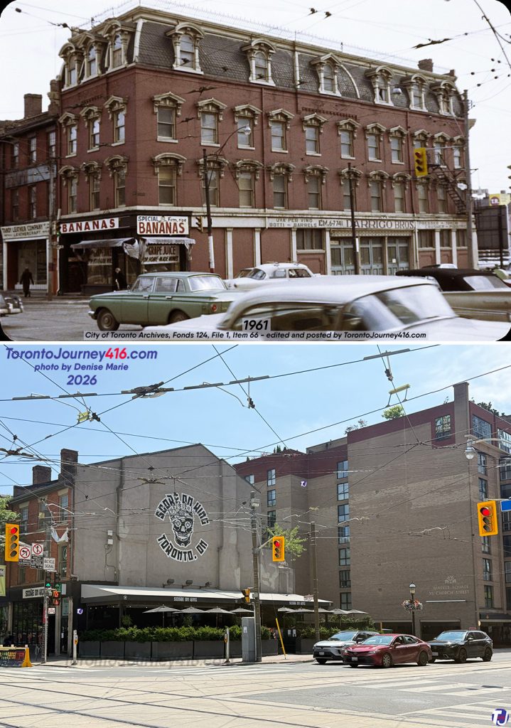
March 1961/July 25, 2026 – Looking southeast towards the corner of King St E and Church St, in the Old Town, St Lawrence neighbourhood of Toronto.

The archive photo features the beautiful 3½-storey building once at the corner. According to a newspaper article, the building dated back to the 1850s. The Victorian-era building had a mansard roof with iron cresting, along with arched and triangular pediments above the windows, which had open, stepped bases. It was home to various businesses throughout its years, including James H. Rogers, a hatter & furrier; Gallagher & Co. fruits; A. Clubb & Sons Ltd. cigars; and finally, Darrigo Bros. grocery and fruit.

By 1970, there were calls to demolish the historic buildings along this stretch. Despite protests to save the structure, the corner building was torn down in 1971. In 1973, the neighbouring buildings along King St E were added to the city's inaugural heritage register
March 1961/July 25, 2026 – Looking southeast towards the corner of King St E and Church St, in the Old Town, St Lawrence neighbourhood of Toronto.

The archive photo features the beautiful 3½-storey building once at the corner. According to a newspaper article, the building dated back to the 1850s. The Victorian-era building had a mansard roof with iron cresting, along with arched and triangular pediments above the windows, which had open, stepped bases. It was home to various businesses throughout its years, including James H. Rogers, a hatter & furrier; Gallagher & Co. fruits; A. Clubb & Sons Ltd. cigars; and finally, Darrigo Bros. grocery and fruit.

By 1970, there were calls to demolish the historic buildings along this stretch. Despite protests to save the structure, the corner building was torn down in 1971. In 1973, the neighbouring buildings along King St E were added to the city’s inaugural heritage register (City of Toronto Archives, Ellis Wiley fonds, Fonds 124, File 1, Item 66)

October 20, 1981/July 25, 2026 - Looking southeast along King St E from Church St in the Old Town, St Lawrence neighbourhood of Toronto.

A few of the establishments visible in the archive photo include Brown Office & Furniture and Marquette; and in both photos, notice the St Lawrence Hall cupola in the centre background
October 20, 1981/July 25, 2026 – Looking southeast along King St E from Church St in the Old Town, St Lawrence neighbourhood of Toronto.

A few of the establishments visible in the archive photo include Brown Office & Furniture and Marquette; and in both photos, notice the St Lawrence Hall cupola in the centre background (City of Toronto Archives, Harvey R. Naylor fonds, Fonds 1526, File 64, Item 19)

June 8, 1952/July 25, 2026 – Looking southwest towards Yonge St from Alexander St in the Downtown Yonge Area of Toronto. The archive photo features the construction of the Yonge Street Subway—now known as Line 1, or the Yonge–University Line. The vintage photo also shows several businesses from right to left, including the Grove Restaurant, Grosvenor Spoke Shop, Empire Wallpaper, and St. Charles Restaurant/Tavern. In the left foreground, a small section of the Grosvenor Hotel is visible. One structure that appears in both photos is the St. Charles Tavern clock tower. The tower dates back to the 1870s and originally served as a hose drying tower when the Yonge Street Fire Hall No. 3 stood at the site. The recently restored clock tower and the facade of the neighbouring building are now part of the Halo Residences condo tower
June 8, 1952/July 25, 2026 – Looking southwest towards Yonge St from Alexander St in the Downtown Yonge Area of Toronto.

The archive photo features the construction of the Yonge Street Subway—now known as Line 1, or the Yonge–University Line. The vintage photo also shows several businesses from right to left, including the Grove Restaurant, Grosvenor Spoke Shop, Empire Wallpaper, and St. Charles Restaurant/Tavern. In the left foreground, a small section of the Grosvenor Hotel is visible.

One structure that appears in both photos is the St. Charles Tavern clock tower. The tower dates back to the 1870s and originally served as a hose drying tower when the Yonge Street Fire Hall No. 3 stood at the site. The recently restored clock tower and the facade of the neighbouring building are now part of the Halo Residences condo tower (City of Toronto Archives, Fonds 16, Series 574, File 82, Item 491032 – Brigdens Limited photography)
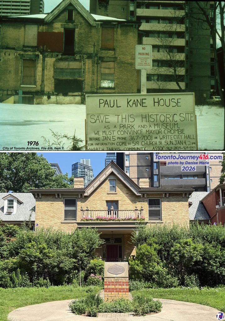
1976/July 12, 2026 – Looking north towards the Paul Kane House, located at 56 Wellesley St E, just east of Yonge St in the Church-Wellesley neighbourhood of Toronto.

Paul Kane (1810-1871) was an Irish-born Canadian painter known for his artwork depicting the landscapes of the West and Indigenous peoples. In the mid-1850s, Kane purchased the property on Wellesley St E and built a stucco cottage, which was later expanded in that decade. After Paul Kane died in 1871, his family continued to live in the home. In 1873, the house was clad with buff brick, and a porch was added. The Kane family owned the house until 1903.

From 1925 until 1973, the building served as a hall for the Evangelical Church of the Deaf. The city purchased the property in 1978 for a reported $500,000, which included $170,000 in support from the province's Wintario funding. The following year, the house was designated under the Ontario Heritage Act, and a city park was created.

The Church Isabella Residents Co-operative later leased the land and abandoned house, and in 1985, with plans by architect Paul Reuber, the Paul Kane House was renovated, divided into two apartments, and incorporated into a residential development that opened in 1986. This house was preserved thanks to the efforts of local residents and heritage organizations.

An interesting note: According to an article in the April 5, 1974, edition of The Toronto Star, "For almost 100 years, everyone except the minister believed that the house had disappeared." This changed in 1973 when a student working for the Toronto Historical Board walked up a laneway beside the former Evangelical Church of the Deaf, which had been built in 1926 directly in front of the Paul Kane House. The student discovered the house and went on to prove that it was originally the home of Mr. Kane
1976/July 12, 2026 – Looking north towards the Paul Kane House, located at 56 Wellesley St E, just east of Yonge St in the Church-Wellesley neighbourhood of Toronto.

Paul Kane (1810-1871) was an Irish-born Canadian painter known for his artwork depicting the landscapes of the West and Indigenous peoples. In the mid-1850s, Kane purchased the property on Wellesley St E and built a stucco cottage, which was later expanded in that decade. After Paul Kane died in 1871, his family continued to live in the home. In 1873, the house was clad with buff brick, and a porch was added. The Kane family owned the house until 1903.

From 1925 until 1973, the building served as a hall for the Evangelical Church of the Deaf. The city purchased the property in 1978 for a reported $500,000, which included $170,000 in support from the province’s Wintario funding. The following year, the house was designated under the Ontario Heritage Act, and a city park was created.

The Church Isabella Residents Co-operative later leased the land and abandoned house, and in 1985, with plans by architect Paul Reuber, the Paul Kane House was renovated, divided into two apartments, and incorporated into a residential development that opened in 1986. This house was preserved thanks to the efforts of local residents and heritage organizations.

An interesting note: According to an article in the April 5, 1974, edition of The Toronto Star, “For almost 100 years, everyone except the minister believed that the house had disappeared.” This changed in 1973 when a student working for the Toronto Historical Board walked up a laneway beside the former Evangelical Church of the Deaf, which had been built in 1926 directly in front of the Paul Kane House. The student discovered the house and went on to prove that it was originally the home of Mr. Kane (City of Toronto Archives, Series 1465, File 616, Item 7 – Urban Design photographs)

May 13, 1983/May 3, 2026 - Looking southwest along King St E from George St, towards Jarvis St in the Old Town, St Lawrence neighbourhood of Toronto.

A few of the businesses in the archive photo include Office Shop Furniture, New Service Grill, Ford Machinery Supply, and Downtown Datsun. The buildings along this stretch, specifically between 167 and 185 King St E, were constructed between the 1830s and the 1850s and are listed on the city’s heritage register. Both photos feature St. Lawrence Hall, built in 1850 and notable for its cupola, with the CN Tower's antenna visible in the background
May 13, 1983/May 3, 2026 – Looking southwest along King St E from George St, towards Jarvis St in the Old Town, St Lawrence neighbourhood of Toronto.

A few of the businesses in the archive photo include Office Shop Furniture, New Service Grill, Ford Machinery Supply, and Downtown Datsun. The buildings along this stretch, specifically between 167 and 185 King St E, were constructed between the 1830s and the 1850s and are listed on the city’s heritage register. Both photos feature St. Lawrence Hall, built in 1850 and notable for its cupola, with the CN Tower‘s antenna visible in the background (City of Toronto Archives, Harvey R. Naylor fonds, Fonds 1526, File 65, Item 77)
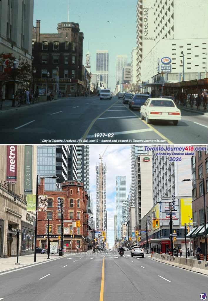
Between 1977-82/May 3, 2026 - Looking north up Yonge St from south of College St/Carlton St, in the Downtown Yonge area of Toronto
Between 1977-82/May 3, 2026 – Looking north up Yonge St from south of College St/Carlton St, in the Downtown Yonge area of Toronto (City of Toronto Archives, Fonds 200, Series 1465, File 616, Item 4 – Urban Design photographs)

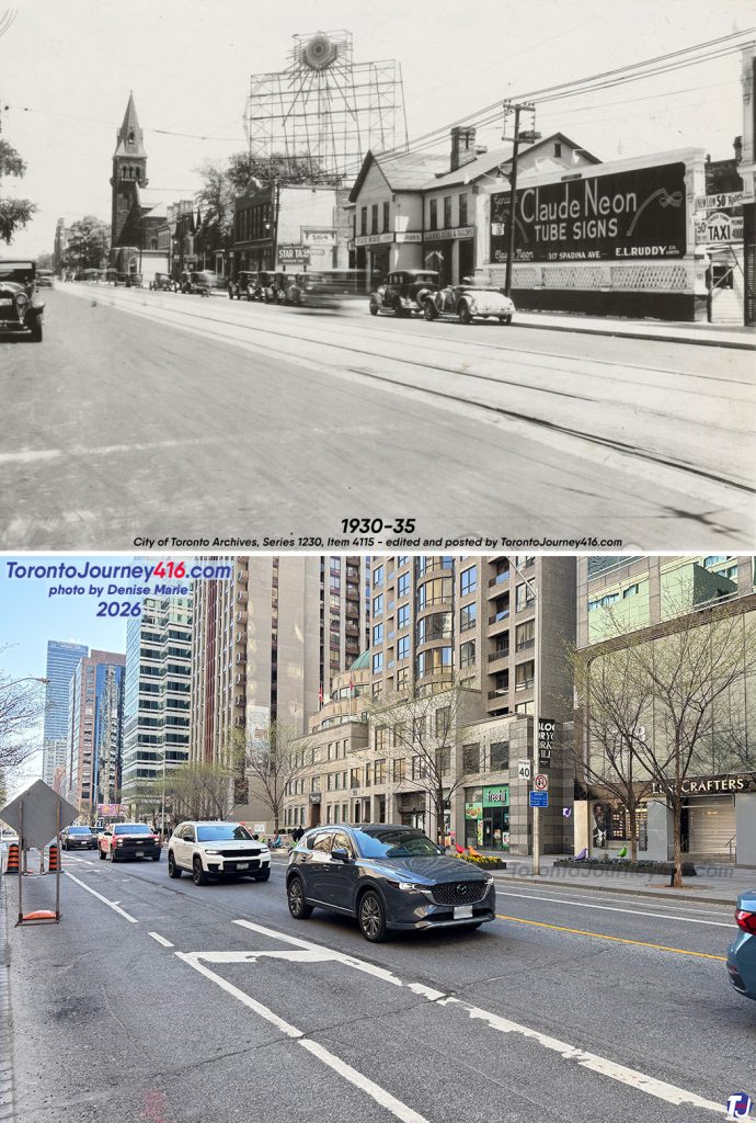
Between 1930-35/May 3, 2026 - Looking southeast along Bloor St E from east of Yonge St, in the Yorkville neighbourhood of Toronto
Between 1930-35/May 3, 2026 – Looking southeast along Bloor St E from east of Yonge St, in the Yorkville neighbourhood of Toronto (City of Toronto Archives, E.L. Ruddy Company fonds, Fonds 1488, Series 1230, Item 4115)

1982/July 12, 2026 – Looking east across Yonge St, between Dundas Sq and Shuter St, in the Downtown Yonge area of Toronto. 

A few of the establishments in the archive photo, from right to left, include Pastificio Restaurant, Saxon Restaurant & Tavern and a portion of Chapman Bros Ltd jewellers
1982/July 12, 2026 – Looking east across Yonge St, between Dundas Sq and Shuter St, in the Downtown Yonge area of Toronto.

A few of the establishments in the archive photo, from right to left, include Pastificio Restaurant, Saxon Restaurant & Tavern and a portion of Chapman Bros Ltd jewellers (City of Toronto Archives, Fonds 620, Item 64 – Avard Woolaver photographer)

SOURCE
  • City of Toronto Heritage Register
  • City of Toronto Heritage Register: Kent Senior Public School at 980 Dufferin St
  • Heritage Toronto
  • Heritage Toronto: Paul Kane Park plaque (56 Wellesley St E)
  • Ontario Heritage Trust
  • Ontario Heritage Trust: 484 Yonge St (St. Charles Tavern clock tower, looking southwest towards Yonge St from Alexander St)
  • The Globe Newspaper Archives: Apr 2, 1926, pg 29 (Evangelical Church of the Deaf, 56 Wellesley St E)
  • The Toronto Star Newspaper Archives: Apr 5, 1974, pg 9 (Paul Kane House, 56 Wellesley St E)
  • The Globe and Mail Newspaper Archives: Apr 5, 1978, pg 8 (Paul Kane House, 56 Wellesley St E)
  • Church Isabella Residents Co-op: About (Paul Kane House, 56 Wellesley St E)
  • National Gallery of Canada: Paul Kane (Paul Kane House, 56 Wellesley St E)
  • The Toronto Star Newspaper Archives: Aug 21, 1970, pg 21 (Darrigo Bros, looking southeast at King St E & Church St)
  • The Toronto Star Newspaper Archives: Apr 3, 1971, pg 13 (Darrigo Bros, looking southeast at King St E & Church St)
  • The Globe and Mail Newspaper Archives: Jun 21, 1952, page 7 (Streetcar track and diversion, looking southwest towards Yonge St from Alexander St)
  • Photos: Denise Marie for TorontoJourney416
  • Vintage Photos: City of Toronto Archives, Toronto Public Library, Archives of Ontario & CNE Heritage
  • City of Toronto: Maps
  • Toronto City Directory, courtesy of Toronto Public Library

LEAVE A REPLY

Please enter your comment!
Please enter your name here

Stay Connected

1,040FansLike
34,068FollowersFollow
118FollowersFollow
8,025FollowersFollow