Past & Present – Part 106

Posted:

May 20, 1927/July 25, 2026 - Looking west along College St from Spadina Ave in the Harbord Village and Kensington Market neighbourhood of Toronto
May 20, 1927/July 25, 2026 – Looking west along College St from Spadina Ave in the Harbord Village and Kensington Market neighbourhood of Toronto (City of Toronto Archives, Fonds 1231, Item 2011 – James Victor Salmon photographer)

Between 1977-83/July 25, 2026 – Looking northeast towards the corner of Yonge St and Alexander St in the Downtown Yonge area of Toronto. 

The archive photo shows Pizza IL’ Panzerotto in the storefront on the left. In the mid-2010s, this building, along with the others on this stretch of Yonge St, was demolished to make way for the Teahouse Condo towers. 

The vintage photo also shows Toronto Workshop Productions (TWP) in the brown-brick building in the background on the right. This building still stands today and has been home to Buddies in Bad Times Theatre since 1994
Between 1977-83/July 25, 2026 – Looking northeast towards the corner of Yonge St and Alexander St in the Downtown Yonge area of Toronto.

The archive photo shows Pizza IL’ Panzerotto in the storefront on the left. In the mid-2010s, this building, along with the others on this stretch of Yonge St, was demolished to make way for the Teahouse Condo towers.

The vintage photo also shows Toronto Workshop Productions (TWP) in the brown-brick building in the background on the right. This building still stands today and has been home to Buddies in Bad Times Theatre since 1994 (City of Toronto Archives, Fonds 200, Series 1465, File 612, Item 9 – Urban Design photographs)

Circa1979/July 12, 2026 – Looking northeast along Yonge St from south of Gould St, in the Downtown Yonge area of Toronto. 

A few of the establishments visible in the right foreground of the archive photo include Jean Junction, Guys & Gals, The Shirt Factory, The Pin Ball Spot, and Music World. These businesses are located in a building constructed in the late 1880s, initially known as the Empress Hotel, and later renamed the Edison Hotel. The site where the old hotel once stood is currently is home to the World Food Market, a collection of food outlets.

In the distant left of the vintage photo is the Canadian Imperial Bank of Commerce, Sam the Record Man and A&A Records. Today, the corner is home to the Toronto Metropolitan University's Sheldon & Tracy Levy Student Learning Centre, which opened in 2015
Circa1979/July 12, 2026 – Looking northeast along Yonge St from south of Gould St, in the Downtown Yonge area of Toronto.

A few of the establishments visible in the right foreground of the archive photo include Jean Junction, Guys & Gals, The Shirt Factory, The Pin Ball Spot, and Music World. These businesses are located in a building constructed in the late 1880s, initially known as the Empress Hotel, and later renamed the Edison Hotel. The site where the old hotel once stood is currently is home to the World Food Market, a collection of food outlets.

In the distant left of the vintage photo is the Canadian Imperial Bank of Commerce, Sam the Record Man and A&A Records. Today, the corner is home to the Toronto Metropolitan University’s Sheldon & Tracy Levy Student Learning Centre, which opened in 2015 (City of Toronto Archives, Fonds 200, Series 1465, File 306, Item 1 – Urban Design photographs)

July 1953/July 12, 2026 - Looking north toward what was previously known as the Almont Hotel, at 3166 Lakeshore Blvd W at Kipling Ave, in the New Toronto neighbourhood of Etobicoke.

The heritage-designated building dates back to 1890 when it opened as a hotel operated by John Shean. By the 1897 Toronto City Directory, the hotel was under new ownership. It continued to change hands throughout the years, operating under various names, including the New Toronto Hotel beginning in 1900. In the early 1930s, it became known as the Almont Hotel, a name it retained until the 1980s. In the late 1980s, it transitioned into Chatters nightclub, followed by Leritz Restaurant, and in the mid 2000s, became the Phantom Lounge.

Today, the historic hotel building is home to the Humber College Fashion Institute
July 1953/July 12, 2026 – Looking north toward what was previously known as the Almont Hotel, at 3166 Lakeshore Blvd W at Kipling Ave, in the New Toronto neighbourhood of Etobicoke.

The heritage-designated building dates back to 1890 when it opened as a hotel operated by John Shean. By the 1897 Toronto City Directory, the hotel was under new ownership. It continued to change hands throughout the years, operating under various names, including the New Toronto Hotel beginning in 1900. In the early 1930s, it became known as the Almont Hotel, a name it retained until the 1980s. In the late 1980s, it transitioned into Chatters nightclub, followed by Leritz Restaurant, and in the mid 2000s, became the Phantom Lounge.

Today, the historic hotel building is home to the Humber College Fashion Institute (Toronto Public Library Pictures-R-2207 – James Victor Salmon photographer)
1972/July 12, 2026 – Looking northwest towards the corner of Dundas St E and Bond St, in the Garden District of Toronto. 

A few of the businesses in the archive photo, from left to right, include the Imperial Hotel, Biggar Lock & Key, Old Stone Mill (clothing), Raffles Restaurant, the Windeler Electric Co. and Shaw Laboratories (dental products), located in the building that features the Reliance Engravers ghost sign. In the background of both photos on the right, the steeple of the First Lutheran Church is also visible.

A portion of this Dundas St E block, from Bond St to Victoria Lane, has been demolished to make way for a 21-storey TMU student residence
1972/July 12, 2026 – Looking northwest towards the corner of Dundas St E and Bond St, in the Garden District of Toronto.

A few of the businesses in the archive photo, from left to right, include the Imperial Hotel, Biggar Lock & Key, Old Stone Mill (clothing), Raffles Restaurant, the Windeler Electric Co. and Shaw Laboratories (dental products), located in the building that features the Reliance Engravers ghost sign. In the background of both photos on the right, the steeple of the First Lutheran Church is also visible.

A portion of this Dundas St E block, from Bond St to Victoria Lane, has been demolished to make way for a 21-storey TMU student residence (City of Toronto Archives, Toronto Planning Board fonds, Fonds 2032, Series 841, File 13, Item 31)

Early 1990s/July 12, 2026 – Looking west towards 570 to 576 Yonge St, from just north of Wellesley St in the Bay-Cloverhill neighbourhood of Toronto. A few establishments in the archive photo, from left to right, include Convenient Plus, Vintage Jeans, Coach House Restaurant, Sonya’s Tea Room, and Fashion Fashion clothing boutique. These 19th-century commercial buildings are listed on the city’s heritage register
Early 1990s/July 12, 2026 – Looking west towards 570 to 576 Yonge St, from just north of Wellesley St in the Bay-Cloverhill neighbourhood of Toronto.

A few establishments in the archive photo, from left to right, include Convenient Plus, Vintage Jeans, Coach House Restaurant, Sonya’s Tea Room, and Fashion Fashion clothing boutique. These 19th-century commercial buildings are listed on the city’s heritage register (City of Toronto Archives, Fonds 200, Series 1465, File 615, Item 7 – Urban Design photographs)

1930s/July 12, 2026 – Looking southwest along Queen's Park from Bloor St W in the University of Toronto – St George Campus area.

Both photos feature the east wing of the Royal Ontario Museum, which was designed by the architectural firm Chapman & Oxley and completed in 1933. It's worth mentioning that the museum's original building, located on the west side, opened in 1914.

The archive photo shows the original location of The Alexandra Gates, which flanked each side of Queen's Park. In the early 1960s, the gates were moved to their present location at the Bloor St W entrance of Philosopher's Walk, on the west side of the ROM
1930s/July 12, 2026 – Looking southwest along Queen’s Park from Bloor St W in the University of Toronto – St George Campus area.

Both photos feature the east wing of the Royal Ontario Museum, which was designed by the architectural firm Chapman & Oxley and completed in 1933. It’s worth mentioning that the museum’s original building, located on the west side, opened in 1914.

The archive photo shows the original location of The Alexandra Gates, which flanked each side of Queen’s Park. In the early 1960s, the gates were moved to their present location at the Bloor St W entrance of Philosopher’s Walk, on the west side of the ROM (City of Toronto Archives, William James Family fonds, Fonds 1244, Item 1140)

1980s/July 12, 2026 – Looking east towards Turko Park and McGill St from Yonge St in the Downtown Yonge area of Toronto. The intersection where McGill St and Yonge St meet was closed in the early 1980s, and a parkette was created. The stone arch shown in the present-day photo, now known as the McGill Street Arch, came from the former St Andrew's United Church building, once located on Bloor St E. The church was demolished in 1981, and its stone arch was preserved, relocated and rebuilt as a pedestrian gateway
1980s/July 12, 2026 – Looking east towards Turko Park and McGill St from Yonge St in the Downtown Yonge area of Toronto.

The intersection where McGill St and Yonge St meet was closed in the early 1980s, and a parkette was created.

The stone arch shown in the present-day photo, now known as the McGill Street Arch, came from the former St Andrew’s United Church building, once located on Bloor St E. The church was demolished in 1981, and its stone arch was preserved, relocated and rebuilt as a pedestrian gateway (City of Toronto Archives, Series 1465, File 36, Item 71 – Urban Design photographs)
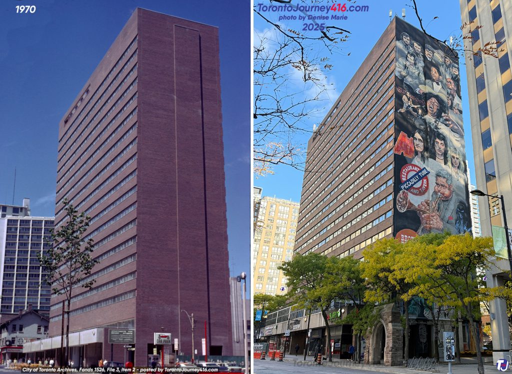
July 1, 1970/November 8, 2025 – Looking northeast towards the 22-storey College View Apartments at 423 Yonge St north of Gerrard St E, between McGill St and Granby St in the Downtown Yonge area of Toronto.

In 2016/17, artist Adrian Hayles painted the Yonge Street Music History murals on the building's south and north sides. The south-facing mural, which is featured in the present-day photo, showcases various musicians and bands, including Lonnie Johnson, Jay Douglas, Salome Bey, Goddo, RUSH, Dizzy Gillespie, Kim Mitchell, Carole Pope, Cathy Young, Jon & Lee from The Checkmates and The Five Rogues
July 1, 1970/November 8, 2025 – Looking northeast towards the 22-storey College View Apartments at 423 Yonge St north of Gerrard St E, between McGill St and Granby St in the Downtown Yonge area of Toronto.

In 2016/17, artist Adrian Hayles painted the Yonge Street Music History murals on the building’s south and north sides. The south-facing mural, which is featured in the present-day photo, showcases various musicians and bands, including Lonnie Johnson, Jay Douglas, Salome Bey, Goddo, RUSH, Dizzy Gillespie, Kim Mitchell, Carole Pope, Cathy Young, Jon & Lee from The Checkmates and The Five Rogues (City of Toronto Archives, Harvey R. Naylor fonds, Fonds 1526, File 3, Item 2)

June 6, 1981/July 12, 2026 - Looking southeast down Spadina Ave from College St in the Kensington Market and Chinatown neighbourhoods of Toronto. 

The archive photo shows the Spadina Ave streetscape, which used to have angled parking. The CN Tower is visible in the background of both images
June 6, 1981/July 12, 2026 – Looking southeast down Spadina Ave from College St in the Kensington Market and Chinatown neighbourhoods of Toronto.

The archive photo shows the Spadina Ave streetscape, which used to have angled parking. The CN Tower is visible in the background of both images (City of Toronto Archives, Harvey R. Naylor fonds, Fonds 1526, File 62, Item 128)

1972/July 12, 2026 – Looking southeast towards the Paint Store at the corner of Baldwin St and Huron St just east of Spadina Ave, in Toronto.

Originally named Reingewirtz Paint and Wallpaper, the shop opened in 1929 when Mr. and Mrs. Reingewirtz started the business in the living room of their family home. In 1956, their son and son-in-law took over the management of the store. During the 1970s, they became the largest seller of Benjamin Moore products in the province. In the shop’s 50th year, the Reingewirtz's grandson, Gary, began working there, and in 1998, a beautiful mural titled “Starry Night” was painted. Third-generation owned, the paint shop has been in operation for over 95 years
1972/July 12, 2026 – Looking southeast towards the Paint Store at the corner of Baldwin St and Huron St just east of Spadina Ave, in Toronto.

Originally named Reingewirtz Paint and Wallpaper, the shop opened in 1929 when Mr. and Mrs. Reingewirtz started the business in the living room of their family home. In 1956, their son and son-in-law took over the management of the store. During the 1970s, they became the largest seller of Benjamin Moore products in the province. In the shop’s 50th year, the Reingewirtz’s grandson, Gary, began working there, and in 1998, a beautiful mural titled “Starry Night” was painted. Third-generation owned, the paint shop has been in operation for over 95 years (City of Toronto Archives, Toronto Planning Board fonds, Fonds 2032, Series 841, File 33, Item 35)

June 23, 1971/May 3, 2026 - Looking east towards Yonge St from Elm St in the Downtown Yonge area of Toronto. A few of the establishments visible in the archive photo, from right to left, include part of Sam the Record Man, Steele’s Tavern, A&A Records, H. Toben & Sons Jewellers and 2by4 Posters
June 23, 1971/May 3, 2026 – Looking east towards Yonge St from Elm St in the Downtown Yonge area of Toronto.

A few of the establishments visible in the archive photo, from right to left, include part of Sam the Record Man, Steele’s Tavern, A&A Records, H. Toben & Sons Jewellers and 2by4 Posters (City of Toronto Archives, Harvey R. Naylor fonds, Fonds 1526, File 3, Item 26)

June 8, 1952/May 3, 2026 - Looking east along Gerrard St from west of Yonge St in the Downtown Yonge area of Toronto
June 8, 1952/May 3, 2026 – Looking east along Gerrard St from west of Yonge St in the Downtown Yonge area of Toronto (City of Toronto Archives, Fonds 16, Series 574, File 82, Item 491033 – Brigdens Limited photography)

Between 1980-90s/May 3, 2026 – Looking south down George St from King St E, in the Old Town, St Lawrence neighbourhood of Toronto
Between 1980-90s/May 3, 2026 – Looking south down George St from King St E, in the Old Town, St Lawrence neighbourhood of Toronto (City of Toronto Archives, Fonds 200, Series 1465, File 51, Item 60 – Urban Design photographs)

April 20, 1981/May 3/2026 - Looking south towards King St E just east of Church St in the Old Town, St Lawrence neighbourhood of Toronto
April 20, 1981/May 3/2026 – Looking south towards King St E just east of Church St in the Old Town, St Lawrence neighbourhood of Toronto (City of Toronto Archives, Harvey R. Naylor fonds, Fonds 1526, File 64, Item 16)

SOURCE

LEAVE A REPLY

Please enter your comment!
Please enter your name here

Stay Connected

1,258FansLike
34,001FollowersFollow
118FollowersFollow
8,043FollowersFollow